History
History
NOMADIC TRIBES TO NORMAN TROOPS
This section contains by far the longest period of history in our website – from the earliest humans who walked and buried their dead in this area dating back over 35,000 years, through to the coming of the Normans about a 1,000 years ago.
This is a fascinating part of our history and although records are often scarce or non existent, the mysteries and myths arising from this period in history fill us with wonder and provide boundless opportunities for our imagination. The section has been divided as follows:
The Stone Age – including the Paleolithic, Mesolithic and Neolithic periods
The Bronze Age – with the influx of new tribes, came new technology
The Iron Age – the powerful Silures tribe who occupied South East Wales
The Romans – a 400 year period when Britain was part of the Roman Empire
The Dark Ages – with the departure of the Romans we are left with few records of this turbulent time
Celtic Saints – the arrival of Christianity into Wales
Welsh Princes – the rulers of Wales who continued to keep the Anglo-Saxons at bay
STONE AGE
No one is certain, but scientific evidence points to the fact that the first humans (Homo Sapiens) date back to around 200,000 years ago.
The Stone Age spans many thousands of years, so it is useful to break this time period into three specific groups. These are:
Palaeolithic: (approximately 200,000BC – 10,000 BC)
The nearest evidence that primitive humans travelled or lived in this area during the Palaeolithic Period can be found at Paviland cave on Gower, which dates back to around 35,000 BC. So there is a strong possibility that primitive man and woman did indeed once tread on the very ground on which we now walk.
Mesolithic: (approximately 10,000BC – 5,000BC)
Beach flints found along the Vale’s coastline serve to suggest hunter/fishermen may have lived here, maybe following their cattle inland in the spring for grazing. The high quality of our agricultural land would have attracted settlers also.
Neolithic: (approximately 5,000BC – 2000BC)
As immigrant tribes became more settled, they began to grow crops. A recent discovery at Brocastle appears to indicate woodland clearance for the purpose of growing barley and corn.
Around 3000BC, new tribes people began to arrive from Europe. Burial sites at Tinkinswood, St Lythan’s and Maes-y-Felin serve to provide solid evidence of their inhabitation of the area.

Did early man fish in these waters?
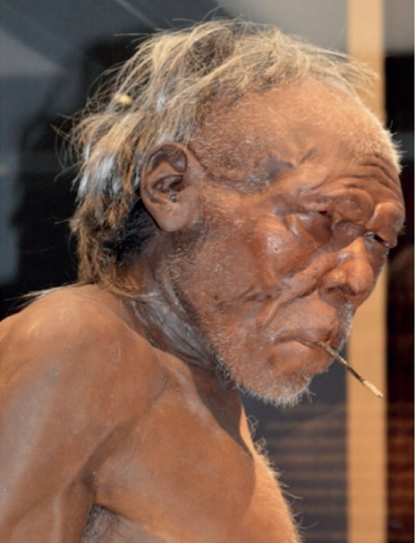
Early man: National Science Museum London

St Lythan’s burial chamber
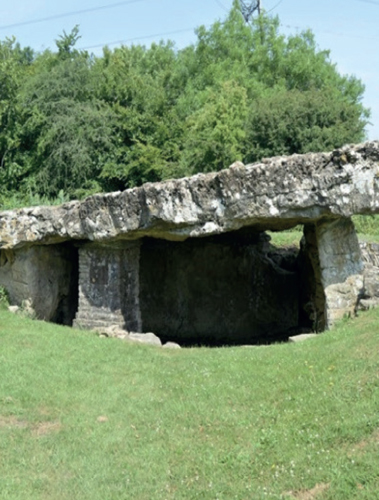
Tinkinswood burial chambers
BRONZE AGE
In the low lying areas of South East Wales the Bronze Age began about 2100 BC, when nomadic people from Somerset began to move into the area.
They came with flocks of sheep and herds of cattle, but they also had the knowledge to make bronze tools and weapons.
Bronze Age people certainly lived around Treoes and the Vale of Glamorgan, for instance: a bronze dagger with a skeleton was found at the old Cowbridge Girls School; there is also evidence of a bronze industry in the area with 3 axes unearthed in Fferm Goch, and a rapier found in City; an early Bronze Age burial site has been found near Llangan School, and further Bronze Age finds have been discovered in nearby Merthyr Mawr.

A more recent find was a 3,000 year old hoard of axes dating from the late Bronze Age. They were found in 2012 with a metal detector near Colwinston. The axes were in remarkably good condition and experts from the National Museum of Wales dated them to between 1000 BC – 800 BC. It has been speculated that the hoard was placed as a gift to a God by a metal working and farming community. The hoard had been purposefully buried some distance from where the nearby dwellings would have stood.
Another even more recent find was a pennanular ring which would have been worn as an ornament. This was found again with the aid of a metal detector in a field near St Donants. The metal in this case was copper, but with a gold foil. These ‘half rings’ were popular forms of decoration and have been found across several sites in Britain and Ireland.

A New Discovery near Treoes!
A recent discovery by Mark Byrne, an archaeology student from Cardiff, revealed an ancient settlement on the outskirts of Treoes.
Mark kindly provided the following explanation:

“The satellite image shows the outline of a large manmade enclosure, that is possibly prehistoric in origin. It is 100m by 80m, surrounded by a 2-3m wide ditch, with an additional enclosure attached to its outer-edge. The main enclosure may have been used for settlement, pasture or arable farming, we cannot see any buildings in this image, so its true purpose is unclear. The additional enclosure is 43m by 33m, again with a 2-3m wide ditch and includes a 22m diameter, roughly circular feature. This 22m feature could be a Round Barrow, a form of ancient burial mound, which could have been constructed after the main enclosure and then connected to it with an encircling ditch – or it existed before the enclosure and was incorporated specifically. Enclosures are often difficult to date from crop marks, this one could date from the Iron Age (600 BC – 43 AD), or Romano British era (43 AD to 400 AD). But a possible Round Barrow at the same site, suggests it would be closer to the Iron Age or even the Bronze Age (2400 BC – 700 BC) if it was constructed before the enclosure.
The strange looking red and white image, is from a technique call LiDar, which uses lasers to measure the shape of the land surface. We can just about see the curved edge of the additional enclosure, where the soil is very slightly built-up as a bank, behind the ditch – though in real life today the height of the ground in the field changes by probably less than 30cm, in the past it may have been 1-2m high, with a ditch 1-2m deep and has now been smoothed out by centuries of ploughing. Inside the curve on the LiDar image we can just about see something that might be circular, this could be all that remains of the circular feature – the potential Round Barrow.”

LiDar Images – “Contains Natural Resources Wales information © Natural Resources Wales and Database Right. All rights reserved”
IRON AGE
An Iron Age fort was built by people who spoke the Celtic language (Brythonic the original language from which Welsh and Gaelic developed), at Tan-y-Lan St. Mary Hill. The proximity of their forts to good grazing and arable land is indicative of their use of agriculture and animal farming. The Celts, who were originally from northern Europe were tall and fair skinned.

Tan-y-LLan Iron Age hillfort, St. Mary’s Hill
The Silures also arrived here about this time, they were swarthy faced people with dark curly hair and probably originated in the Iberian area of Spain.
Both tribes were strong and warlike. The tribes were named Silures and Celts by the Romans whom they resisted fiercely. Interestingly both tribes wore red in battle – a tradition carried on today by our national teams although they are battling in a different field.

Evidence of their intense occupation of the Vale exists in the abundance of finds unearthed. Middens (dumps of domestic waste) have been unearthed, containing a high density of pig bone, plant remains, pottery, metalwork and human bone. The high density of pig bone suggests a gathering place where communal feasting would take place.
ROMANS
Despite their fierce resistance, the Silures eventually succumbed to Roman rule.
There are many examples of Roman occupation in the Vale of Glamorgan.
It is suspected that the remains of a settlement called Bovium (place of Cows) has been found under the town of Cowbridge. A Roman bath house was discovered there, which has bricks stamped by the 2nd legion, suggesting some kind of military establishment. Funerary monuments of persons of status including a finely sculpted lion have also been found, as well as evidence of industry including agricultural processing and large scale ironworks. (Source Wikipedia)

Depiction of a Roman soldier
In 1997 the remains of shops and houses were discovered in Coopers Lane, and excavations behind Bear Lane have revealed that the military and civilian presence may have been sizeable (Source History of the Vale). Romano-British pottery of the 3rd century has been found near Llangan School.
The Roman road named Via Julia Martina, built to service the garrisons throughout Wales, runs roughly on the same route as the current A48 road, which is very close to Treoes. This was an important Roman road at the time.
DARK AGES
The departure of the Romans from Britain did not happen overnight, but by the year 410 AD, their influence and control was largely over.
At this time almost all of Britain was occupied by different Brythonic Tribes and there was no country called Wales. From about the middle of the 5th century onwards a series of Germanic tribes started to invade and settle in Britain, largely in the South and East of what is now England. The term ‘Wales or Welsh’ was coined by these Anglo Saxon tribes and means ‘foreigner.’


This period in history is associated with King Arthur, a British warlord that fought off Saxon invasion. But did King Arthur exist, and if so where was he based?
The legend of King Arthur, Camelot, the Knights of the Round Table comes from the writings of a monk called Geoffrey of Monmouth in the 1100s, therefore, the depiction of Arthur as knight in armour and fighting on horseback, with high walled stone castles is a total misrepresentation. If Arthur did exist, he was a fierce chieftain who somehow managed to galvanise the independent Brythonic tribes to join forces and hold off the invasion of the Saxons, Angles and Jutes from Northern Europe.
Did King Arthur live in what is now Wales? The forensic historians, Wilson and Blackett, think he did – and that in fact history has muddled up two Arthurs who lived 250 years apart! The first was associated with Romanised Britain, whilst the second ruled over what is now South East Wales.

There are historical records that Arthur fought 10 battles against the Saxons, with the last one being staged at Mount Badon. There is a mountain called Badon near LLangenwyd- could this be the site of Arthur’s legendary victory over the Saxons?
Wilson and Blackett have undertaken considerable research and their theories are certainly very interesting – whether you agree with them or not!
So, could the legendary King Arthur have walked only a few miles from what is now Treoes? No one knows, and we can only speculate.
CELTIC SAINTS
From around 550 AD onwards a number of Celtic Saints arrived in Britain, many coming from what is now Brittany in France.

One of the most important of these Saints was Illtyd, who established a church and teaching college at LLantwit Major. This could well have been the first university in Britain. It was certainly the most important centre of learning for many years. The Welsh name for LLantwit Major is LLanilltyd Fawr, which means the church of the great Illtyd.
Illtyd had a very significant impact of the early Celtic Church and as well as teaching and mentoring many other holy men and women who were later recognised as saints themselves, such as Saint Patrick, Saint David, Saint Samson (associated with Caldy Island) and Gildas the historian. Illtyd is sometime referred to as Illtyd Farchod, that is, he rode a horse and was a knight. Somewhat unreliable sources in the 1100s refer to him as King Arthur’s cousin.
The church at Llangan is dedicated to St. Canna who was reputedly the sister-in-law of Saint Illtud. Saint Canna was a princess from Brittany who first settled around what is now Cardiff, giving her name to Pontcanna and Canton (Treganna in Welsh).
The Celtic Wheel Cross at Llangan is of the 9th or 10th century. Located near the west wall of the church is a disc-headed cross slab, 1.3m high, depicting the crucifixion, set now in a shelter to prevent further erosion from the weather.
Just below the Church at LLangan there is an area of boggy ground, around 10m from the stone wall that encloses the burial ground. This could be a former Holy Well or spring associated with Saint Canna.
Saint Canna later moved to Carmarthenshire where there is another Church and Holy Well named after her.


Canna was also supposedly the mother of St Crallo, who established a church at Coychurch (LLangrallo in Welsh).
The present day church is a Grade 1 Listed Building.
WELSH PRINCES
Once the Anglo Saxon Germanic tribes had established control over what is now England, the Brythonic tribes were confined to the Western areas of Wales, Cornwall and Northern Britain.
In Wales, this was a period when local chieftains ruled, squabbled and sometime grew in power. The Welsh tradition of dividing a father’s lands evenly between his sons often resulted in sibling rivalry and a grasp for power.

This was also the start of a series of Viking raids, where they plundered many coastal monastic sites.
What is now Treoes lay in the small Celtic kingdom of Cernyw, a western chunk of the former Silures territory. In around 420 AD Cernyw was subjected to a series of fierce raids along its coastline. Irish raiders sailed up the Severn and seized a large amount of booty in the form of corn and cattle; they also took children and women as slaves.
There are legends that they kidnapped the young St Patrick from the College at Llantwit Major.
In 437 AD Cernyw and the adjoining territory of Ewyas were combined by Owain Finddu (Owain Black Lips in Welsh), who was possibly the son of the most powerful Romans in Britain, Magnus Maximus. (Magsen Wledig in Welsh).
In 470 AD Glwys came to power and Cernyw was renamed Glywyssing in his honour. For the next 100 years Glwysiog was ruled as three territories with an overlord controlling the entire territory. These comprised of:
- Gwynllg which formed the far eastern part of Glywyssing, divided from Gwent by the River Usk, with a capital at Allt Wynllyw on Stow Hill (in Newport)
- Penychen divided from Gwynllg by the River Elerch, otherwise known as the Greater Rumney, which was ruled from Nant Pawl.
-
Gorfynedd the westernmost section, which included what is now Glamorgan and the Gower Peninsula and which was ruled from Llaniltud Fawr (Llantwit Major).
In 580 the King of nearby Gwent, Meurig, gained control of Glywyssing through marriage and unified the two Kingdoms until 745.
In 735 Ithel ap Morgan became ruler of Gwent, Glywyssing and Ergyng and therefore King of all of South-East Wales. Around this time Gwent extended east of the River Wye into what is now the Forest of Dean.
Around 745 Ithel divided the joint kingdom between sons, with Brochwal ap Ithel ruling Gwent and Rhys ap Ithel ruling in Glywyssing. Ithel made sure that he was recognised as their overlord.
The Kingdom remained relatively stable throughout the remainder of the eighth and into the ninth century.
In 942 Morgan Hen Fawr (Morgan the Old), became king of Glywyssing and Gwent under the new name of Morgannwg (modern Glamorgan).
At this time the Saxons in England were gaining in power and Morgan was subjected to the over lordship of Athelstan, who was based in Hereford.
The Kingdom once more broke up after the death of Morgan in 972, but a new force was about to the exerted on the area.
In 1055 Gruffudd ap Llywelyn conquered all of what is now Wales.
He was the only King to control all of the country – from Anglesey to Glamorgan.

Territory controlled by Gryffydd ap LLewelyn
This was therefore a period of great turbulence, with territories changing hands often. For the most part. the Welsh Kings had kept the Saxons at bay, remaining largely independent until 1066 AD, when everything changed for the Anglo Saxon, and later for the Welsh as well.

Depiction of Norman soldiers
In 1066 AD the Saxon King Harold Godwinson was defeated by William Duke of Normandy. The Normans rapidly established control over England, becoming the aristocratic rulers of the Anglo- Saxons.
Wales remained independent, but William had rewarded his most loyal general with large territories along the border between England and Wales. These were know as the Welsh Marches and the nobles had the authority to keep their own armies – with the primary focus of ensuring the Welsh were not posing a threat.
There was however a quiet migration to the Vale of Glamorgan of people of Irish, Norse and Anglo-Saxon descent from places such as Somerset. The Vale thus became an area of mixed population, with some unsympathetic to the cause of Welsh Independence who were happy to acquiesce to Norman rule when it came.

RESTORATION

HISTORY